 버전
5.1.0 free
버전
5.1.0 free
 패키지명
com.atlogis.hispaniola.free
패키지명
com.atlogis.hispaniola.free
 카테고리
여행하다
카테고리
여행하다
 크기
5.78MB
크기
5.78MB
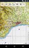
Topographic maps and aerial imagery for Dominican Republic and Haiti
Easy to use outdoor and offline navigation app with 1:50.000 seamless topographic maps of Dominican Republic and Haiti.
Use this navigation app for outdoor activities like hiking, biking, camping, climbing, riding, canoeing or offroad 4WD tours.
This app gives you similar mapping options as you might know from Garmin or Magellan GPS handhelds.
Available map layers:
• Topographic maps 1:50.000 and 1:250.000 with seamless coverage for complete Hispaniola Island (Dominican Republic and Haiti).
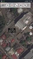
• Google Maps (Satellite images, Road- and Terrain-Map)
• Bing Maps (Satellite images, Road-Map)
• Open Street Maps (OSM Mapnik and Cloudemade Cyclemap)
• Hillshading overlay layer for OSM, Google or Bing maps
Main features for outdoor-navigation:
• Free bulk-download of map tiles for OFFLINE USAGE (NOT in this free version !)
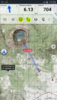
• Create and edit Waypoints
• GoTo-Waypoint-Navigation
• Create and edit Routes(NOT in this free version !)
• Route-Navigation (Point-to-Point Navigation) (NOT in this free version !)
• Track Recording (with speed, elevation and accuracy profile)
• Tripmaster with fields for odometer, average speed, bearing, elevation, etc.
• GPX/KML/KMZ - Import/Export (NOT in this free version !)
• Search (placenames, POIs, streets)
• Customizable datafields in Map View and Tripmaster (eg Speed, Distance, Compass, ...)
• Share Waypoints, Tracks or Routes (via eMail, Facebook, ..)
• See your location with UTM coordinates
• Tablet optimized layouts
• and many more ...
LIMITATIONS OF THIS FREE VERSION:
• Ads
• No Bulkdownload of maps for offline usage
• No Hillshading overlay
• 최대. 3 Waypoints
• 최대. 3 Tracks
• No Routes
• No import of waypoints and tracks
• No Bulkdownload
On the 1:50.000 maps you'll find many small roads, pathes and 4WD tracks that are not included in Google, Bing or OpenStreetMaps. The topo maps have a very detailed topography with contour lines. 이 지역의 강, 호수, 언덕, 식생, 마을 등과 같은보다 자세한 지리적 기능을 제공하는 다른 온라인 매핑 서비스/앱은 없습니다.
The topo maps layer is a seamless mosaic of more than 200 georeferenced maps. 지도 중 일부는 상당히 오래되었지만 (지도의 생산 범위는 1966-2002) 야외 여행에 여전히 매우 좋습니다. 특히 모험적인 경로 나 버려진 장소를 보는 경우에는 여전히 좋습니다. Most maps of the Dominican Republic were created in the late 80ies. Within the app you can open an overview map with the publishing dates of the maps.
대도시에서는 Google 또는 OSM지도로 전환하는 것이 더 유용하지만 오지에서는 대규모 지형지도의 관련성을 인식 할 수 있습니다.
1 : 250.000 맵은 지형 및 항공 차트 모두로 의도 된 중간 규모의 맵을 나타내는 조깅 (Joint Operations Graphic)입니다.
The topographic maps are enhanced with Atlogis® hillshading and placenames.
1 : 50.000 토포 맵의 최초 출판사 : 미국 NGA (National Geospatial-Intelligence), NIMA (National Imagery and Mapping Agency), DMA (Defense Mapping Agency)
Original publisher of the 1:250.000 topo maps: US NGA/NIMA JOG (Joint Operations Graphics)
Please send comments and feature requests to [email protected]


 다운로드 APK(5.78MB)